“I’ve been battling it out very hard for three weeks. At times I was at the cusp of jumping into the void. I didn’t want to let go but I wanted it all to end. I don’t know how I managed to survive the latest onslaught. Somehow I did. The cave was dark. It was cavernous. It felt hopeless. There’s light. I want ran towards it even though I am very exhausted. I staggered towards the light… Slowly. Slowly.”
May 27, 2018
I woke up in a place that felt unfamiliar. Beside me is Saul. Then it all came back to me. We are in Marinduque. It was just a random thing. He was looking for a companion to join him in his wandering. I was free so I joined him. Besides, I badly needed a weekend off from the bustling metro.
The main objective of our weekend escape is to climb Mt. Malindig. We were supposed to climb it on our first day in Marinduque but due to our late arrival in Marinduque, we decided to hold off the plan and do instead in the second day of our stay. We spent most of our first day cavorting around the island, zooming from one part to another. We started in Boac and ended up in Poctoy Beach where we spend the night before our hike.
We woke up early for two reasons. One, we wanted to catch the sunrise. Two, we wanted to start our climb early. As always, the sunrise was mesmerizing: a sign for good things to come. After a brief photo session while watching the sun rise, Saul and I prepared our things for the highlight of our weekend excursion.
It was still too early so Saul and I agreed to just hire a tricycle to take us to the Barangay Sihi in Buevanista municipality. Barangay Sihi is the jump-off point for Mt. Malindig climbs. After about an hour’s drive, we reached the barangay hall where registered; it is required. We also had to pay a registration fee of PHP 45.00 and avail the services of a guide (for PHP 500.00). It is important to register first as some arrangements are needed to be done to be allowed to go to the summit.
With everything in order, we begun our ascent at about 8:20 AM. We passed through the village before finding the trailhead. With our surrounding swiftly changing, we found ourselves in the company of tall coconut trees. This is not surprising considering that it is one of the island’s primary produce.


It was a pleasurable hike. That was until we reached the grassland and the open trail. The open trails gave us a wide overview of the valley below us. However, it also meant punishment because of the scorching heat. We had to endure the heat for an hour. Like hapless dogs, we ran towards every possible shade we came across while climbing.
It all got better when we reached the military outpost two-hours into our hike. To get to the summit, we have to pass through the military outpost. Please note that permits are required to be allowed to pass through the outpost. The need for a special permit makes availing a guide compulsory. We had to wait for the officer-in-charge before proceeding to the summit. It took some time before we got the green light but we didn’t mind because it allowed us time to catch our breath.
Once cleared, Saul and I resumed our trek to the summit. Again, the vegetation started to transform. From coconut plantations to open grasslands, the trail changed into a mossy forest. This is more bearable compared to the open trail. It was cooler. However, the reprieve was temporary as the trail became steeper.


Mt. Malindig’s brand of mossy forest is reminiscent of Mts. Maculot and Arayat. It is a mix of dry and wet mossy forest, which makes it more interesting. It also has its own distinct texture that sets it apart from others. It is one of the mossy forests that didn’t give me that eerie feel. Come to think of it, Mt. Malindig is one of two mountains (the other one is Mt. Malipunyo) that made me appreciate the beauty and the diversity of mossy forests.
Reaching the mountain’s summit was an achievement but the best moment happened while we were climbing to the summit. While Saul and I were focusing on our ascent on the steep trail, our guide abruptly stopped. He pointed something that was obscured by the tall fern plants. In confusion, we peeked into what he was showing us. Lo and behold, he was showing us a live bird’s nest! It had three brown-spotted eggs. In my nearly two years of climbing, I thought I’ve seen it all but this one is for the records. It was truly astounding witnessing something like that. My mouth was agape at the sheer beauty of it. Even Saul was fascinated. It was his first time as well. Mother Nature never fail to impress.


As we were nearing the summit, we heard the loud buzzes of a thousand bees. Our guide pointed up and we saw the source – a big chunk of beehive. Cautiously, we crossed the trail and made it to the summit.
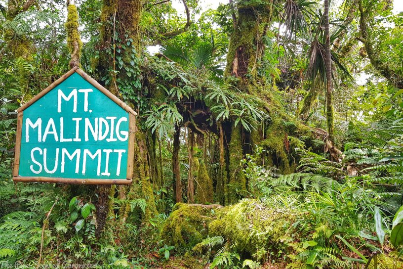
There is no view at the summit; it was shrouded by tall trees. However, it was a very placid spot, perfect for ruminating. The summit area reminded me of the summit area of Mt. Pack (Mt. Purgatory traverse). Mosses and lichens carpeted the tree trunks, making it a very idyllic spot for picture taking. I didn’t mind the lack of view because everything was beautiful. As I have realized, each mountain has its own character that makes it special.
To give my readers a background, at 1,157 MASL, Mt. Malindig is the highest point in the province of Marinduque. It is a dormant stratovolcano from which the province’s name is believed to be derived from. The presence of sulfuric hot springs on its base is a suggestive evidence of its volcanic nature.


After snapping pictures, we had our lunch then we started our descent. The climb was made special by some guide dogs who joined our climb. I am not sure if the dogs were owned by our guide but they’ve been with us from start until descent. It took us four hours to complete the backtrail hike. We concluded it where we started – at the coconut plantation. To quench our thirst, we bought some coconut. It was refreshing after that draining climb.
Wah. Although I didn’t expect it, I was spellbound by Mt. Malindig. It was an amazing hike and it was an amazing weekend off from the stresses of my quotidian life. But something saddened me though. Our guide mentioned how most of the mountain is being converted into farmlands through kaingin. This method of land conversion is particularly dangerous as it could cause forest fires. I am not sure if it was before or after but within a day of our climb, a portion of the mountain was destroyed by a forest fire.


