This is the second part of my Mt. Ugo adventure last July 9, 2017. To read the first part, click here.
After everyone was done with their lunch, we began our descent to Tinongdan at around 12 noon. The first phase of the descent is quite challenging because it is a little steep. Moreover, the open trail is a bit narrow. Making up for the challenging descent is the idyllic view which includes a view of the Binga Dam and the towering peaks of the Cordilleras.
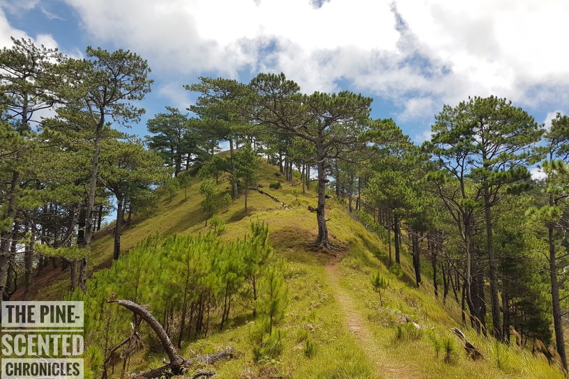
Past the steep-angled trail, the trail became more pleasant. We again entered a pine-covered forest, a truly enchanting sight. It was so beautiful it felt like it was taken out of one of Hans Christian Andersen’s fantasy-riddled books. The scene was serene, tranquil, and simply beautiful. These wonderful sights remind me of the reasons why I try to escape the urban living bedlam whenever the opportunity presents itself.
For the most part, I got to navigate the trail on my own because, just like on the ascent, the descent trail is well established. While scaling the trails alone, I just felt a sense of inner peace. Although my mind is also filled with the stories of climbers who, when they found themselves alone, got lost because of “some elements who were intentionally making them go round and round the trails.” No mountain is safe from such tales.


On my own, I just continued my descent down Mt. Ugo as though I have always known the trail. There are also some concrete markers which showed the distance to the jump-off point. The markers were set up by a popular seller of outdoor activity wear and give hikers a perspective on how far they are from the end of the trail. As I drew nearer and nearer to KM 0, I can barely keep my excitement. With each kilometer I cover, my strength is restored.
Before long, signs of human activities replaced the thick vegetation of the pine forest. We first reached a rice field which means that we are near the village. However, we had to wait for our guide because the trails split into different directions. Thankfully, we reached the first village without getting lost. Being the first ones to reach the village, we immediately looked for cold drinks to quench our thirst and to cool down our warm bodies. Fortunately, there is a store at the village, an oasis of hope for the exhausted climber.


When majority of us reached the village, we again resumed our descent to Tinongdan. We then again entered another pine forest, with the tall trees providing cover against the rays of the scorching afternoon sun. However, once we got past the pine forest, the trail became open and more steep. Cognizant that I no longer have sufficient water with me, I tried to run down the trail. In my months of climbing, I have learned a great deal about my body. One of these things I have learned is that I don’t eat much food but I drink a lot of water. I guess I owe it to the rate at which I sweat.
The last phase of the trail down to Tinongdan is quite tricky because it is filled with loose rocks. Moreover, it has become narrow and a quick slip will make one hurtle down into the deep abyss. While keeping my momentum, I exercised maximum caution even though I got more and more desperate for water with every distance I covered. But the heat was really draining me.
When I finally saw the KM 3 sign, I breathed a deep sigh of relief. This is still far from the target but it is such a relief that I am drawing closer with every step. The trail is getting narrower but I am too excited to even slow down a bit. And then from a far, I saw signs of human activities. Fellow hikers were crowding a halo-halo stall. Because my tongue was already parched, I feasted on the halo-halo as well. I thought this was the jump-off point already but I soon learned from the locals that I have about a kilometer more to walk before reaching the jump-off point.


My spirits would have deflated at the news but instead, I got more excited because the cold halo-halo revived my waning spirit. After my quick respite, I proceeded to the jump off point with a renewed vigor. I found myself alone on the trail, again. Thankfully, the pathway to the village is clearly established and easy to follow. It was quite daunting though because one side of the trail is a deep chasm that goes directly to the river below. But the view though is amazing as always. It reminds me of home.
After about an hour, I finally got a glimpse of the village. The first thing I did upon reaching the village is to look for water. Unfortunately, all the stores I approached had no bottled water to sell. Left with no choice, I proceeded to the jump off point, sweaty and thirsty. I had to use my umbrella as a shield against the scorching afternoon sun. When I finally reached the hanging bridge, I was filled with great relief because I know I am about to approach the finish line. At the hanging bridge, I met my fellow climbers who went ahead of me. However, they failed to solve the maze of the village pathways and got waylaid. To avoid such incidents, never be too shy to ask the locals for directions.
After taking a couple of pictures at the bridge, we trudged on with the final stretch of the trail, the end in sight. Finally, after 12 hours of trekking, I was finally able to complete my fourth mountain in four weeks, and my fourth major climb as well. It is also my first 30+ kilometer trail. Whew, that was one great adventure.


Till the next mountain!
