December 3, 2017
It’s been a month since I’ve climbed a mountain. My last was at South Korea’s Ulsan Bawi Rock, my first international hike. Sadly, after that Korean excursion, I have fallen into a spell of sedentary lifestyle. My procrastination made me long for a new adventure. Then I came across a hiking group’s event page for a climb to Batangas’ Nalayag Rock. A friend recently climbed the monolith and I was jealous of her pictures so I mustered the courage to join the climbing event.
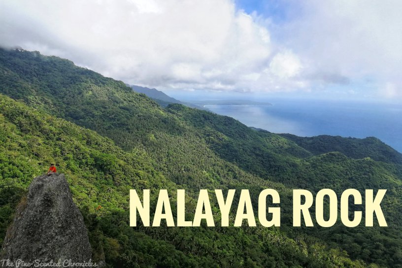
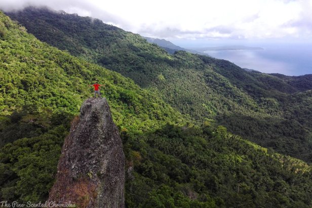
Nalayag Rock has become a popular hiking destination because of its idyllic and prominent phallic shape. Hikers can climb the monolith and take a captivating picture of the mountains and the sea. To make the trip more memorable, I invited a friend over. JC accompanied me on my hike to Rizal’s Mt. Maynoba last February 2017. Thankfully, he relented and hence, I am on my way to adding yet another mountain to my growing list of mountains climbed.
The Climb
Our meeting time is early. At around 2 AM on Sunday morning, I was already up and about. The group is to pick me and my friends at EDSA Ayala Station because the designated meeting place is quite far from where we live. Thankfully, we did not miss the van that was to pick us up. And zoom towards the south we go! It is going to be quite a long ride though as Lobo is located nearly at the tip of Batangas.
After over three hours on the road, we have finally reached our destination. The sun has already risen over the eastern horizon; the community beside the sea has woken up from its slumber. Well, so did I! I tried to get my bearings and checked on my surroundings. It was a very brilliant morning and the sea is glistening under the morning light. As the organizers were busy arranging matters with the barangay officials, some participants prepared their things while some had coffee to warm up their rigid bodies.
Our climb started with the requisite pre-climb routine: orientation and group prayer. Nalayag Rock derived its name from its shape which is in the shape of a “sail”. Literally translated, “nalayag” means sail in English. When everyone was ready, we proceeded with the climb proper. Time check: 6:40 AM. The first phase of our climb is quite pleasant and easy because we were navigating a winding river track. We simply followed the river tracks and took some rests whenever necessary.


There wasn’t much incline during this part although at times the trail goes up and down. The real challenge came after about 20 minutes later. The trail slowly transformed into a more treacherous terrain even though we were still following the river track. There was even a part where we had to cross an inundated bridge. Climbers should be very careful when crossing because the bridge is unstable.
About an hour into the climb, we turned right towards the mountain, finally leaving the river track. There were parts that were thickly covered by tall trees while there were some parts that opened to wide grasslands. The incline was gradual and not as physically taxing. We passed by areas where locals burn coconut husks and turn them into charcoal. The smell of burned husk permeated in the air. As the mountain is located near the sea, coconut trees are all over the area. It is the local’s major source of livelihood.
At around 8 AM, we reached a private property where coconut is farmed. We rested for a while before proceeding with the rest of the climb. From where we were resting, Nalayag Rock can be seen. It was so near yet so far; according to our guide, we still have about two more hours before we can reach the rock. When all of the climbing participants have gathered at the coconut farm, the first group proceeded with the climb.


The trail after the private property can be very confusing as there were a lot of trails that lead to different areas. It is best to wait for your guide or let your guide be the forefront of your group. Along the trail to Nalayag Rock are numerous watering holes where cows and carabaos graze. We encountered some of these mammals while we were climbing. And then the really challenging part came. To get to Nalayag Rock, we must climb a very steep trail.
What made the assault very challenging is the wet trail, still damp from the morning dew. Even though I was at the forefront of the lead group, I had to take utmost caution because I was unassisted. The trail was straightforward although I had to let my instinct lead me; one can easily lose one’s bearing because of the thick foliage. About 45 minutes of tackling the steep assault, I finally reached the base of Nalayag Rock where the cold mountain breeze greeted me.
The breeze was very refreshing, especially after that hapless ascent. The area offers a magnificent view of the sea and the surrounding mountains; Lobo is where the mountains meet the sea. I was also able to spot, from a distance, the resort in San Juan, Batangas where my company held its 2017 summer outing. Surrounded by this invigorating view and place, my body and soul has switched into a very relaxed mode, considering that I just had a very challenging morning. Haha!


When everyone reached the base of the rock, everyone became busy snapping pictures. There are two monolithic structures in the area which are situated next to each other. The first rock is bigger than Nalayag but its shape is less prominent. It is also used as the vantage point for taking pictures of its more popular neighbor. Caveat: the climb going up the rock is treacherous. We first had to climb a long ladder before dealing with another steep and slippery ascent Utmost caution should always be observed.
One by one, we had our pictures be taken at the famous Nalayag Rock. The climb to Nalayag Rock is equally treacherous as the first; a long rope ladder is used to climb up the miniscule rock. Atop the rock, the wind was ravaging us. The space at the top of the rock is very limited and provides very little room to wriggle. Those who were overwhelmed by the wind chose to sit down while those who were courageous enough stood up while their pictures are being taken.
We started our descent at around 11 AM. Unfortunately, we could not climb to the summit of Mt. Masalakot because of a recent slide which left the trail unnavigable. The climb down was less challenging, as expected. The narrow trail eventually opened up to a wide provincial and rough road which was once used by quarriers to bring down rocks from the mountain. When one of the organizers started running, I joined in and let gravity do its job. It was a bit painful for me because I was wearing my climbing sandals instead of my shoes. It was fun, nevertheless, and within an hour, we have reached the base where a small community is situated.


We waited for everyone at a sari-sari store. Once complete, we proceeded to our next destination, Malabrigo Beach. Exhausted and weary, we were all looking forward to a healing time at the shores. It took thirty minutes to reach the beach. The first thing that sprung out before us is the lighthouse. It is an antiquated structure perhaps built during the latter parts of the Spanish period because of its Spanish-inspired structure. If I am not mistaken, the lighthouse has been used as a shooting location for some local movies. It is not surprising because of how idyllic it is.
From the lighthouse area, we climbed down to the beach. It is not your typical beach though because instead of fine sand, the shore was accentuated with rocks. Yep, it is a rock beach. The beach is very clean though, one of the cleaner ones I have seen, or probably because it was less crowded? Hmmm. Much as I would want to dip into the inviting waters, I backtracked because of the scorching heat. The heat and the exhaustion left me dozing out and by the time I woke up, it was time to leave already.
Nevertheless, my stress was relieved by another weekend with nature. Once in a while, it does help to get away from what is stressing you.
Happy climbing!
P.S. The climb was organized by Outdoor Buddies Unbounded. To join their climbing events, you can check their Facebook Page.
